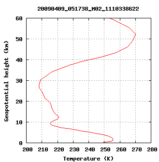
GRM-02/41: NRT Temperature Profile
(NTPMEA/NTPMEB)
 |
| _ | Values | Remarks |
| Units | Kelvin (K) | _ |
| Domain | 0-50 km | Surface to ~1 hPa |
| Range | 180-350 K | _ |
Requirement
on target
accuracy | 0-5 km: 2-3 K
5-30 km: 1 K
30-40 km: 1-5 K
40-50 km:
5-10 K | _ |
Requirement
on vertical
resolution | 250-500 m | Depends on back-
ground pressure levels |
| GRM-02 status | Operational | Metop-A |
| GRM-41 status | Operational | Metop-B |
Current product version (GRM-02): 1.0
Current product version (GRM-41): 1.0
| _ |
|
Product description
The NRT temperature product contains a profile of temperature as a function of height (geometric and geopotential) above the EGM-96 geoid.
Algorithm description
Each product profile is the result of one radio occultation. Signals from the occulting GPS satellite are measured by the GRAS receiver onboard the EPS/Metop satellite, downlinked, and processed by the ROM SAF into refractivity. More details can be found in the
Algorithm Theoretical Baseline Document, on the
Radio Occultation Theory page, and in the Validation Report for
GRM-02 and GRM-41.
Data characteristics
GRAS measures about 700 GPS occultations per day. The product is output in both NetCDF and BUFR format, and disseminated via GTS/RMDCN (BUFR) and EUMETCast (NetCDF and BUFR). NetCDF files are also stored in the ROM SAF
Product Archive.
Product validation and monitoring
Accuracy of the current version of the product will be described in a future Validation Report. Daily monitoring of the processing and dissemination can be seen on the
Monitoring Page.
Product documentation
All ROM SAF NRT and Offline products are described in the
Product User Manual.
This product will be made available at the
Product Archive.


