
The Radio Occultation Method
Atmospheric parameters based on satellite measurement of GNSS (Global Navigation Satellite System) signals. For more information on radio occultation theory see the list of articles and reports under Publications.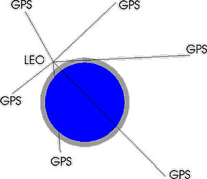 Weather prediction is based on the most realistic description possible of the
state of the atmosphere from a numerical model. These models have reached a stage,
where their representation of reality is more dependent on the available observations
for initialization of the prediction computations, than on the mathematical model
itself. Especially regular observations from ocean areas will be able to improve
the statistics of prediction of the state of the atmosphere more than two days ahead.
Satellite observations of meteorological standard parameters is one way of achieving
a better and evenly distributed global data coverage.
Weather prediction is based on the most realistic description possible of the
state of the atmosphere from a numerical model. These models have reached a stage,
where their representation of reality is more dependent on the available observations
for initialization of the prediction computations, than on the mathematical model
itself. Especially regular observations from ocean areas will be able to improve
the statistics of prediction of the state of the atmosphere more than two days ahead.
Satellite observations of meteorological standard parameters is one way of achieving
a better and evenly distributed global data coverage.
Radio Occultation is a rather new method for indirect measurement of temperature, pressure and water vapour in the stratosphere and the troposphere. The technique is based on utilizing the radio signals continuously broadcast by the GNSS satellites (GPS/GLONASS/Galileo) orbiting the Earth at an altitude of about 20000 km above the surface. The GNSS radio signals are influenced both by the electron density in the ionosphere and by the temperature, pressure and water vapour in the atmosphere.

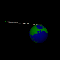
From the point of view of a Low-Earth-Orbit (LEO) satellite (at an altiude of 700-800 km) the GNSS satellites will ceaselessly rise above, or set behind, the horizon of the Earth. During these so-called "radio occultations", where the GNSS and the LEO satellite are just able to "see" each other through the atmosphere, the GNSS signals will be slightly delayed and their ray path slightly bent on the way through the ionosphere (twice) and the atmosphere. On the LEO this is observed as differences in the phase and amplitude of the received signals. The two figures above show the ray paths of the GNSS signals on their way to the LEO satellite, and how the ray paths are bended during an occultation.
 To have a closer look at the geometry of a typical GPS occultation see the following
visualization.
To have a closer look at the geometry of a typical GPS occultation see the following
visualization.
A typical occultation sounding will last one minute, and during this minute the LEO satellite will receive signals where the ray paths have different minimum distances to the surface, from zero up to approximately 100 km. The GNSS satellites transmit on two different frequencies, and with a receiver rate of 50 Hz this will yield around 6000 rays, making up two profiles of phase residuals up/down through the lowest 100 km of the atmosphere and the ionosphere.
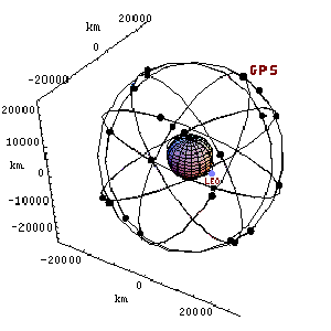
The figure below shows the earth with a low-earth-orbiting LEO satellite (800 km above surface) and 24 GPS satellites located approximately 26000 km from the earth's center. The GPS satellites orbit the earth once every 12 hours whereas the LEO takes approximately 100 minutes for one orbit. It is also possible to view an animation of the orbiting satellites (approx. 400 KB).
With precise knowledge of the position and velocity of the LEO and GNSS satellite it is possible, using geometrical considerations and inversion methods, to compute a profile of the atmospheric refractivity in the position where the individual ray path has passed closest to the surface. By assumptions of hydrostatic equilibrium, the equation of state, and a simple connection between the refractive index and density of the atmosphere, a temperature and density profile can be computed in this location.
The largest error source in the observation and analysis method is the ionosphere, which is highly varying in space and time. These fluctuations have a large impact on the inversion of the observations, and knowledge of the state of the ionosphere is important for achieving good results.
The radio occultation technique was originally developed at Stanford University and JPL (Jet Propulsion Laboratory) for studies of planetary and lunar atmospheres. Only in the last couple of years the method has been investigated with a view to using GNSS signals for obtaining atmospheric parameters for the Earth. The method first proved itself after the spring '95 launch of the american Microlab-1 satellite, which has a GPS TurboRogue receiver onboard. This experiment has the official name GPS/MET. The results were promising and showed good agreement with radio sonde temperature measurements within a few Kelvin, and a surprisingly good resolution of small temperature irregularities around the tropopause.
Since then several research GPS receivers have been/are operating aboard different LEO satellites, and the first operational system for weather prediction and climate research, GRAS, is onboard EUMETSATs series of EPS/Metop satellites, the first of which was launched in 2006.
|
|

|

|
|
|